
Phone GPS vs RTK: How Accurate Do You Need to Be?
Phone GPS is typically accurate to a few meters in open sky. A compatible RTK receiver can provide centimeter-level positions with a correction service, internet, and suitable conditions. The right choice depends on how much error your job can tolerate, not simply whether you need an area or a point. A rough acreage estimate may be fine on a phone; marking a planned point or measuring a small plot can need a more precise method.
The short answer
| Phone GPS | RTK receiver with corrections | |
|---|---|---|
| Typical horizontal accuracy | About 5 m (16 ft) under open sky | Often rated around 1–2 cm + 1 ppm; equipment and conditions matter |
| What you need | A phone and an app | A receiver, an RTK correction service, an internet connection, and open sky |
| Good for | Acreage, rough locations, planning | Layout, fence and irrigation work, precise records |
The phone figure comes from GPS.gov: GPS-enabled smartphones are typically accurate to within a 4.9 m (16 ft) radius under open sky. The RTK figure is the rating receiver makers usually publish. The National Geodetic Survey’s guidelines for single-base real-time positioning note that many manufacturers state RTK accuracy as 1 cm + 1 ppm horizontally and 2 cm + 1 ppm vertically. For example, the GNSS module in Dipper Go by InsightSpatial is rated at 0.8 cm + 1 ppm horizontally (CEP 50%, open sky, baseline under 1 km). That “+ 1 ppm” means accuracy loses about 1 mm for every kilometer between you and the reference station.
A receiver that does not use corrections sits in between. A good multi-band receiver on its own is usually better than a phone, but it does not reach centimeters. We will publish Dipper Go’s results without corrections after field testing.
What accuracy does your job need?
Start with the error you can accept. The size of the site, nearby buildings or trees, and how you capture each point all matter. Check a phone measurement against a known distance before using it to order materials or mark a location.
| Job | Accuracy that works | What to use |
|---|---|---|
| Estimating acreage for seed, spray, or a quote | A few meters may be sufficient | Phone for an estimate |
| Rough fence-line length for a materials estimate | A few meters may be sufficient | Phone for an estimate |
| Finding a spot again roughly, such as a well or gate | A few meters may be sufficient | Phone for an estimate |
| Setting fence posts along a planned line | Set a tolerance for the job | Consider RTK or another suitable measuring method |
| Placing irrigation heads or valve boxes from a plan | Set a tolerance for the job | Consider RTK or another suitable measuring method |
| Marking footings, posts, or planting grids | Set a tolerance for the job | Consider RTK or another suitable measuring method |
| Research plots and sample points you must revisit | Set a tolerance for the job | Consider RTK or another suitable measuring method |
| Legal property lines | Survey-grade, by a licensed surveyor | A licensed land surveyor |
The last row matters. No phone, receiver, or app you use yourself can establish a legal boundary. If the question is where your property line is, call a licensed surveyor.
What does RTK need?
RTK needs four things to work:
- A receiver that can use corrections. Most phones cannot use RTK corrections, so you connect an external receiver such as Dipper Go to the phone.
- An RTK correction service. Corrections come from a reference station at a known position. Many US states run public networks, and commercial networks cover large areas. See What are RTK and NTRIP? for where to find one.
- An internet connection. Corrections usually arrive over the internet. Cellular works, and so does satellite internet such as Starlink. Without any connection, you will not get centimeter-level RTK positions.
- Open sky. Trees, buildings, and steep terrain block satellites. RTK needs a good view of the sky to stay at its best.
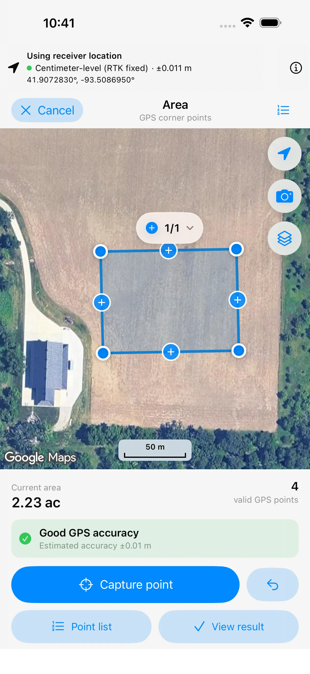
An RTK fixed status means the receiver has resolved the satellite signal ambiguities needed for precise RTK positioning. It is not an independent accuracy guarantee: a wrong reference position, blocked sky, or reflections can still affect the result. RTK float means that step is not complete, so do not treat it as a centimeter-level result. Good apps show you which one you have. Dipper Area Measure by InsightSpatial, for example, shows “Centimeter-level (RTK fixed)” with an estimated accuracy for every point.
How can you check the accuracy you are getting?
Do not take any number on faith, including ours. A few simple checks tell you whether your setup is doing what you need:
- Watch the status. With RTK, capture points only when the app shows a fixed solution. A float solution can look fine on the map and still be off by tens of centimeters.
- Read the estimated accuracy. Receivers and apps report an estimate for each position. It is the receiver’s own estimate, not a guarantee, but a sudden jump usually means something has changed: a tree overhead, a lost correction stream, or fewer satellites.
- Measure a known point. The National Geodetic Survey publishes positions for survey marks across the US. Find one near you with the NGS datasheets, set up over it, and compare. Make sure your app and the datasheet use the same coordinate system.
- Measure the same spot twice, at different times. Satellites move, so the conditions an hour later are different. If two RTK measurements of the same point agree within a couple of centimeters, you can trust the setup for layout work. The NGS guidelines recommend repeat visits a few hours apart for the most demanding work.
With a phone alone, try the same thing: capture a fence corner, walk away, come back, and capture it again. The difference between the two is a good feel for what “a few meters” means in your yard or field.
What does it cost?
- Phone only: the phone you have, plus an app. Dipper Area Measure is free, with no ads and no account.
- Receiver: a one-time purchase. Dipper Go’s price will be announced before launch.
- Correction service: it may be free or paid, with eligibility, coverage, and fees set by the provider. Check your state network, such as Missouri’s network or North Carolina’s network, or compare commercial providers. Confirm current terms before choosing a service.
- Internet: the data plan you already have is usually enough. Corrections use a small amount of data.
Checklist: phone or RTK?
Answer yes or no:
- Do you need to put something in the ground at a planned position?
- Will you or someone else need to find the exact spot again later?
- Would an error of 3 to 5 m cost you time, materials, or a redo?
- Are you measuring a small area, such as a garden or a building lot, where a few meters is a large share of the total?
- Do you need heights or slopes, not just positions?
If you answered no to all five, start with your phone and check whether the result is good enough. If you answered yes, compare RTK with other measuring methods and check the tolerance your job requires. For property lines or work that calls for a qualified professional, get professional help rather than relying on an app alone.
* Centimeter-level positioning requires a compatible RTK receiver, a correction service, an internet connection, and open sky. Actual results depend on equipment and conditions. Map tracing depends on the imagery and where you place points.
InsightSpatial apps and devices are for measuring, layout, and record-keeping. They do not replace a licensed land surveyor and should not be used to establish legal property lines.
Products mentioned: Dipper Area Measure · Dipper Go