
What Are RTK and NTRIP? A Plain-Language Guide
RTK (real-time kinematic) is a way to make a GNSS receiver accurate to a few centimeters. A reference station at a precisely known position measures the same satellites you do, works out the errors, and sends corrections to your receiver in real time. NTRIP is the standard way those corrections travel over the internet. Together they let a small receiver connected to your phone do work that used to need survey equipment.
What is RTK?
Every GNSS position has errors: the satellite signals are delayed as they pass through the atmosphere, satellite clocks and orbits are slightly off, and so on. A base station (also called a reference station) sits at a known spot, so it can see exactly how wrong its own position is. Because a nearby receiver sees almost the same errors, the base station’s measurements can be used to correct it.
Your receiver, called the rover, combines its own measurements with the base station’s. RTK uses not only the satellite codes but also the phase of the radio waves themselves, which is far more precise. When the rover has worked out the exact number of wave cycles to each satellite, it reports a fixed solution, which enables centimeter-level positioning in suitable conditions. Before that, it reports a float solution. Neither status alone proves absolute accuracy; reference coordinates, signal reflections, and setup still matter.
Why does distance to the base station matter?
The farther you are from the base station, the less its errors look like yours, because you are under a different piece of sky. Receiver makers express this as a “parts per million” figure: the National Geodetic Survey’s real-time positioning guidelines note that most specify 1 ppm. For example, the GNSS module in Dipper Go by InsightSpatial is rated at 0.8 cm + 1 ppm horizontally. One ppm is 1 mm per kilometer, so 20 km from the base adds about 2 cm.
The same guidelines recommend keeping a single base station within 20 km (12 miles) for routine centimeter work, and within 10 km (6 miles) for the most demanding jobs. Beyond that, it takes longer to reach a fixed solution and the fix is less reliable. Network services avoid this problem by creating a virtual reference station close to you, which is why they ask your receiver for its approximate position.
What is NTRIP?
NTRIP (Networked Transport of RTCM via Internet Protocol) is the standard protocol for sending RTK corrections over the internet. The corrections themselves are in a format called RTCM. To connect, you need four things from your correction provider:
- Caster address and port. The caster is the server that distributes correction streams. Port 2101 is common.
- Mountpoint. The name of the stream you want. A provider can have hundreds: one per base station, or one per network product.
- Username and password. Most services require an account, even the free ones.
- Whether to send your position. Network and “nearest base” mountpoints need your receiver’s approximate position, which the app sends as a GGA sentence. Good apps do this automatically.
Corrections are small: usually a few kilobytes per second or less. A phone’s cellular data is usually enough, and satellite internet such as Starlink works where there is no cell signal. Without any internet connection, you will not get RTK corrections.
Where do I get corrections?
There are three main options in the US:
- State and public networks. Many state departments of transportation and geodetic survey offices run real-time networks of reference stations, and several are free after registration. Search for your state’s name with “real-time network” or “CORS”. The NOAA CORS Network, managed by NOAA’s National Geodetic Survey, combines stations from hundreds of government, academic, and private organizations. Its data is mostly used for post-processing, but it is a good place to find who runs stations near you.
- Commercial networks. Subscription services with wide coverage and support. Good if you work across a large area or need a guaranteed service.
- Your own base station or a community caster. You can set up your own base station and stream its corrections. Community casters such as RTK2go let people share their base stations for free. Coverage is uneven, and you are relying on someone else’s equipment.
An InsightSpatial RTK correction subscription is planned. Today, Dipper Area Measure can connect a compatible receiver to a supported NTRIP service. Check the provider’s coverage and correction formats. Dipper Go is in development; tested device compatibility will be published before launch.
Are there alternatives to RTK?
RTK is the usual way to get centimeters in real time, but it is not the only kind of correction. Knowing the others helps you read receiver specs and choose a service:
- SBAS (WAAS in the US). The FAA’s Wide Area Augmentation System broadcasts corrections from geostationary satellites, so it needs no internet connection and no account. Many receivers use it automatically. It makes a position more reliable and somewhat more accurate, but it does not reach centimeters.
- PPP (precise point positioning). PPP services send precise satellite orbit and clock corrections instead of data from a nearby base station, so they work far from any reference station. The trade-off is time: a PPP position usually takes much longer to settle than an RTK fix.
- Post-processing. If your receiver can record raw satellite data, you can process it later against reference stations, for example with NOAA’s OPUS service. This needs no internet in the field, but you only get the precise result afterwards, so it does not help with layout.
For staking out points, finding a spot again, or anything where you need to know you are in the right place while you are standing there, RTK is the practical choice.
How to connect in Dipper Area Measure
Area Measure has a built-in NTRIP client, so you do not need a separate app.
- Connect your RTK receiver to the app over Bluetooth LE or Wi-Fi.
- Add your correction service: caster address, port, username, and password.
- Choose a mountpoint, or let the app choose the nearest base station for you.
- Wait for the status to reach Centimeter-level (RTK fixed) before you capture points.
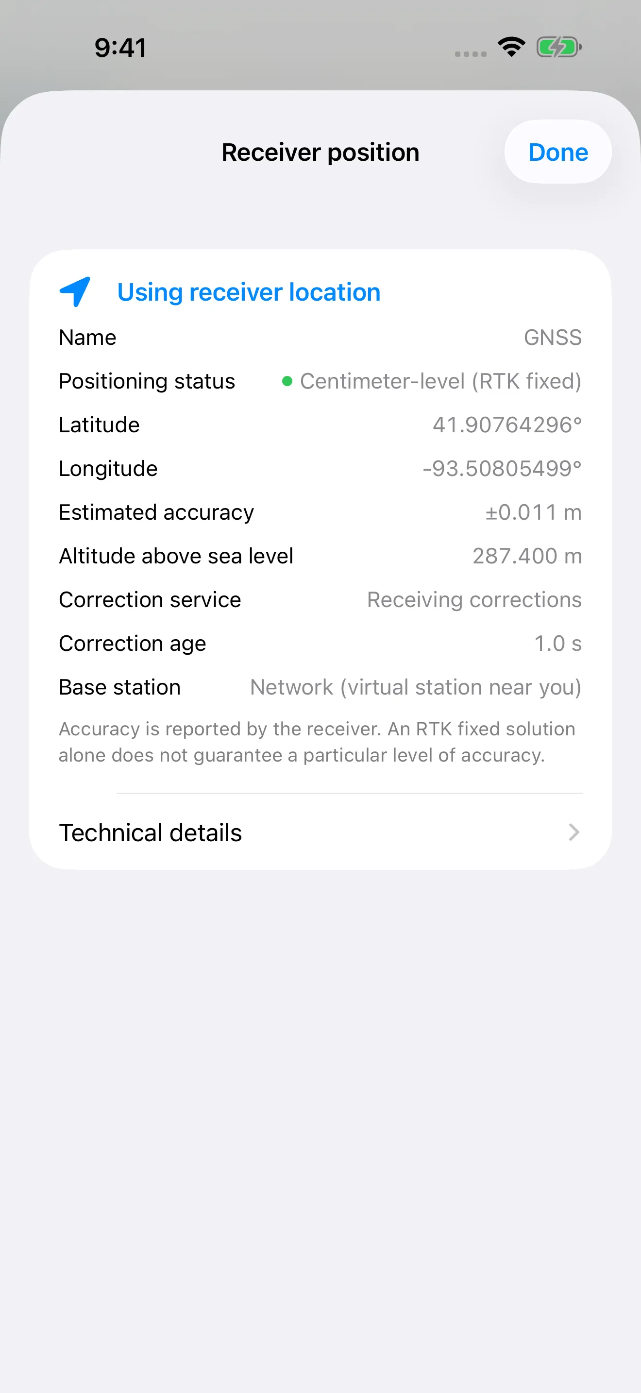
The receiver screen shows the fix status, the receiver’s accuracy estimate, whether corrections are arriving, and how old they are. Correction age should stay at a second or two. If it climbs, your internet connection is struggling. For step-by-step help, see the Area Measure help center.
Troubleshooting: no fix
If the receiver stays in float or never gets corrections, check these in order:
- Sky view. Move away from trees, buildings, and vehicles. RTK needs to see a lot of satellites at once. The sky plot in Area Measure shows how many satellites you are using.
- Corrections arriving. If correction age is missing or growing, check your internet connection, your username and password, and the caster address and port.
- Mountpoint. Make sure the mountpoint suits your receiver. Check that the provider supports your receiver’s correction format, satellite systems, and signals. More bands alone do not guarantee better accuracy.
- Distance. If you are using a single base station more than a few tens of kilometers away, choose a closer one or a network mountpoint.
- Position sent. Network mountpoints need your position. If you get no data at all from a network mountpoint, check that the app is sending GGA.
- Time. After you connect, give the receiver a minute in open sky to reach a fixed solution.
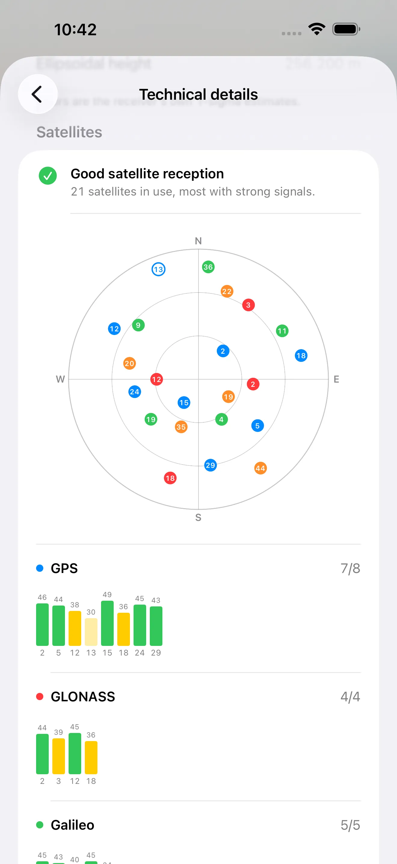
Centimeter-level positioning requires a compatible RTK receiver, a correction service, an internet connection, and open sky. Actual results depend on equipment and conditions. Map tracing depends on the imagery and where you place points.
InsightSpatial apps and devices are for measuring, layout, and record-keeping. They do not replace a licensed land surveyor and should not be used to establish legal property lines.
Products mentioned: Dipper Area Measure · Dipper Go